Free original lessons
Draw Pakistan's Outline and Province Boundaries
Learn to draw a Pakistan political map from an official reference, label its four provinces, and check the grid and boundary line conventions.
Free lesson
Four exercises
Worked answers
Object Drawing Lessons
This lesson copies Pakistan's national outline and provincial boundaries from one dated official political-map reference onto a measured grid; it does not invent geographic coordinates. The NSDI catalogue lists the Political Map of Pakistan 2020 (5th Edition), an official dated edition that should be identified as the 2020 map rather than called current: NSDI catalogue entry for the 2020 fifth edition. A later publication, the Pakistan Bureau of Statistics National Census Report 2023, includes a political map credited to Survey of Pakistan. Choose one dated source and record its full title and year; if you need the latest administrative depiction, check the NSDI catalogue and PBS GIS page for a newer edition before drawing. PBS lists Balochistan, Khyber Pakhtunkhwa, Punjab, and Sindh as provinces, with Islamabad Capital Territory, Azad Jammu & Kashmir, and Gilgit-Baltistan shown separately. Topographic detail, city maps, and neighboring-country outlines are outside this task. All grid dimensions are hypothetical.
Practice materials: Printable downloads are not available for this lesson yet. Use the instructions and four exercises below.
Reference illustration
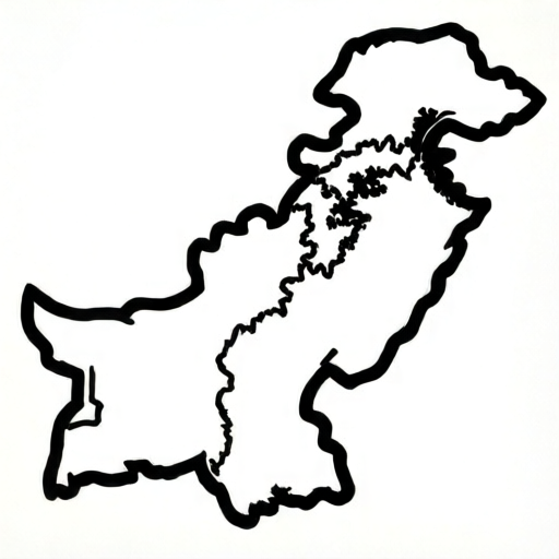
Use the stated measurements and conventions for each exercise.
Set up the grid and the line convention
Choose one dated official political map and keep it visible beside your paper. The NSDI 2020 fifth edition is a dated reference, not automatically the current edition; record the title and year you actually use. If recency matters, check the official catalogue for a later edition before copying. For a four-province practice map, label Balochistan, Khyber Pakhtunkhwa, Punjab, and Sindh. Do not label Islamabad Capital Territory, Azad Jammu and Kashmir, or Gilgit-Baltistan as provinces; use the categories shown by the source map.
Draw a hypothetical 12-column by 8-row grid with 2 cm squares, making a 24 cm by 16 cm drawing area. Label columns A to L from left to right and rows 1 to 8 from bottom to top. The grid is a copying aid: mark the north, northeast, east, southeast, south, southwest, west, and northwest turning points by looking at the official map, then add intermediate points wherever the coastline or border changes direction.
Choose one line convention: a solid national outline, dashed internal provincial boundaries, and short perpendicular sea-side ticks only if you need coastline markers. Keep all marks inside the grid and note the map title and date in the margin.
- Open a dated official political map and record its title and year.
- Draw the 12 by 8 grid and label columns and rows.
- Transfer the eight broad direction anchors and then the visible turning points from the map.
- Use solid outline, dashed province boundaries, and a written legend.
Place national outline points by grid coordinates
Copy the country outline in one direction around the edge, starting at a point you can identify on the reference. Place the broad north, east, south, and west extents first, then mark intermediate turns from the official map. Use the grid to keep relative positions consistent; do not reuse coordinates from an unrelated practice polygon as if they described Pakistan.
Join the points in order with short straight strokes, smoothing only where the official outline visibly curves. Close the national outline at the starting point and compare its overall proportions and major bends with the source map. If you change the grid scale, keep the country shape proportional rather than stretching one axis.
- Mark the broad north, northeast, east, southeast, south, southwest, west, and northwest extents from the chosen reference.
- Add intermediate points at visible changes in the coastline and land border.
- Join adjacent points with the solid outline convention.
- Close the outline and compare its proportions with the official map.
Add province boundaries and coastline markers
Add the provincial boundaries by copying their actual routes from the same official map. Label Balochistan in the west and southwest, Khyber Pakhtunkhwa in the northwest, Punjab in the east and center, and Sindh in the southeast, checking each placement against the reference. Boundary lines should meet the national outline or another boundary where the map shows them meeting; do not draw a line across open space just to make an even-looking partition.
Use dashed lines for provincial boundaries so they remain distinct from the solid national outline. If you add coastline ticks as a drawing aid, place them only on the seaward side of the coast and keep them short and consistent. The map source, not a guessed grid coordinate, determines the geographic location of every boundary.
- Copy the four provincial boundaries from the same dated map as the national outline.
- Label the four provinces in the locations shown by the reference.
- Check that boundary endpoints meet the outline or another boundary where appropriate.
- Keep the provincial lines dashed and the national outline solid.
Check the drawing with simple arithmetic
Check the grid arithmetic separately from the geography. With 2 cm squares, 12 columns give 24 cm of width and 8 rows give 16 cm of height. Compare the widest and tallest spans of your traced outline with the map in the same orientation; the grid should help you preserve relative proportions, not create fictional coordinates.
Count the four province labels and check each against the official reference. Confirm the line key is consistent: solid for the national outline, dashed for provincial borders, and optional short ticks for the seaward coast. Record the source title and date so another reader can identify which boundary map you copied.
- Multiply columns and rows by the square size to verify the drawing area.
- Compare the outline's broad proportions and turning points with the official map.
- Check that all four province names and placements match the reference.
- Review the line key and record the source title and date.
Worked example
Use the NSDI Political Map of Pakistan (2020, fifth edition) as a dated reference, or choose another dated official political map and record its title and year. On a 12 by 8 grid with 2 cm squares, transfer Pakistan's outline, then label the four provinces and give one arithmetic check.
Worked answer
Copy the national outline from the selected dated official political map into the grid, preserving its broad shape and coastline. Add dashed provincial boundaries and label Balochistan, Khyber Pakhtunkhwa, Punjab, and Sindh in the positions shown on the reference. The drawing area is 24 cm by 16 cm because 12 × 2 = 24 and 8 × 2 = 16. Record the source title and date beside the map; the grid values are only a drawing scale, not geographic coordinates.
Why: An official reference supplies the actual geographic shape and boundary routes; the grid supplies repeatable placement. Keeping those roles separate avoids confusing a schematic geometry exercise with a real map.
Check: Count the 12 columns and 8 rows, multiply each by 2 cm, and compare the outline and each province label with the chosen official map.
Four practice exercises
Exercise 1
On a 10-column by 8-row grid with 1.5 cm squares, copy Pakistan's national outline from the NSDI Political Map of Pakistan (2020, fifth edition) or another dated official political map; identify the edition as a dated source, not as a claim that it is current. Mark the north, east, south, and west extents before joining the outline, and record the source date.
Show answer and check
A closed outline transferred from the dated official political map with the four broad extents placed first, intermediate turns added from the reference, and the map date recorded in the margin. The grid measures 15 cm by 12 cm.
Why: The official map provides the geography while the grid makes positions repeatable. Broad extents give a first check before smaller boundary turns are copied.
Check: Multiply 10 × 1.5 cm and 8 × 1.5 cm. Compare the four extents and the closed silhouette directly with the selected official map.
Exercise 2
Using the same reference map, add dashed boundaries for Balochistan, Khyber Pakhtunkhwa, Punjab, and Sindh. Label each province where it appears on the map and keep the national border solid.
Show answer and check
Four province labels appear in the source-map locations: Balochistan to the west and southwest, Khyber Pakhtunkhwa in the northwest, Punjab in the east and center, and Sindh in the southeast. Provincial boundaries are dashed; the country outline is solid.
Why: The map's categories and locations determine the labels. A separate line style makes the internal boundaries readable without changing their route.
Check: Count four province names, compare their placements and boundary routes with the source, and verify that every provincial line uses dashes while the national outline remains solid.
Exercise 3
A 12-column by 8-row practice grid uses 2 cm squares. Calculate its width and height in centimetres. Then state how the grid should be used when copying a curved coastline.
Show answer and check
The grid is 24 cm wide and 16 cm high. Mark several points along the coastline from the official map and join them with short strokes that follow the reference curve.
Why: Twelve columns times 2 cm gives 24 cm, and eight rows times 2 cm gives 16 cm. Multiple reference points preserve the coastline better than one guessed straight line.
Check: Recalculate 12 × 2 = 24 and 8 × 2 = 16. Trace the coastline against the official reference and confirm the line passes through the marked turning points.
Exercise 4
Inspect the chosen official map and identify one place where a provincial boundary meets the national outline and one place where it joins another boundary. Draw those segments with the stated line key and explain how you checked them.
Show answer and check
The two locations are copied from the same dated political map. The national edge is solid and the province lines are dashed; each copied boundary meets the other line at the location shown in the source.
Why: Boundary endpoints must follow the map's actual junctions. The line key distinguishes the national perimeter from internal provincial borders.
Check: Compare both junctions against the source map at the same orientation and verify that no endpoint stops short or continues across open space.
Common mistakes
- Joining outline points in the wrong order, which creates crossing lines. Work clockwise from one starting point and number the points before joining. Check that the line returns to the start without crossing itself.
- Letting province boundary lines stop in open space. Extend each boundary line until it meets the national outline or another boundary, then recount the endpoints.
- Using the same line style for the national outline and province boundaries. Apply the convention: solid for the national outline, dashed for province boundaries, short ticks for coastline. Recheck each line type.
- Placing coastline ticks on inland boundaries. Add ticks only where the outline meets the sea, on the seaward side, and keep them evenly spaced.
Self-check rubric
- National outline is copied from a named official map and forms a closed shape.
- Four provinces are labeled and placed according to the selected reference.
- Provincial boundaries follow the map and meet the outline or another boundary at the shown junctions.
- The grid dimensions and square size are consistent.
- Solid and dashed line conventions are distinct and used consistently.
- The map source title and date are recorded.
Questions and answers
Are the grid coordinates in this lesson official map coordinates?
No. Grid labels are paper-placement aids. Use the official political map for the actual outline and boundary routes, and record its date.
Which areas should be labeled as provinces in this exercise?
The PBS GIS reference lists Balochistan, Khyber Pakhtunkhwa, Punjab, and Sindh as the four provinces. Follow the source map's separate categories for other areas.
Can I use a static map image?
Yes. Record its title and year and compare it with the current official GIS page, since administrative maps can change.
Do I need coastline ticks?
No. They are an optional drawing aid. If used, keep them on the seaward side of the national outline and out of inland boundaries.